
Can Landscapes Create Culture? Caria as a Cultural Ecosystem and Spatial Technology of Attention, by Timea Kutlu
If you stand on the high, arid plateau above the Marsyas Valley in southwestern Turkey and look toward the horizon, the Aegean world appears to fragment into a labyrinth of stone. Jagged limestone massifs, deeply gouged by winter torrents, rise abruptly out of fertile alluvial pockets. Dense stands of maquis and wild olive twist out of thin topsoil, while subterranean waters carve hidden channels through the karst beneath your feet.
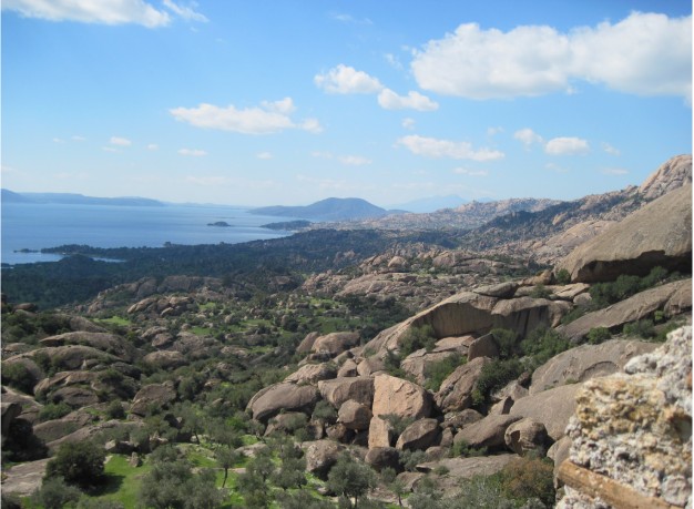
This is Caria. Today, its coastline is familiar to millions who flock to the turquoise bays of Bodrum or Marmaris, navigate the wooded shores of Datça, or visit the more famous monumental centres of western Anatolia, such as Ephesus. Yet just inland, within a broken terrain of mountain massifs, enclosed basins, and river valleys, lies a landscape that classical history has quietly struggled to place.
To historians trained on the grand narratives of the Mediterranean, Caria has often presented an interpretive irritation, unsettling many of the conventional metrics through which ancient civilizations have been classified. Even when the Hekatomnid dynasty transformed Halicarnassus into a monumental capital, no single urban centre permanently absorbed the region’s political, religious, and territorial identities. It left behind no unified, overarching state apparatus that could be neatly mapped across a single century. Although many Greek poleis articulated civic identity through a strongly defined urban centre, Carian communities often made the relationship between city, territory, route, and extra-urban sanctuary unusually visible.
Ancient authors offered no single, stable definition of the Carians. Herodotus preserved competing accounts of their origins, while other traditions associated them with maritime mobility, military service, inland strongholds, and sanctuaries whose local identities did not fit neatly within later Greek categories.
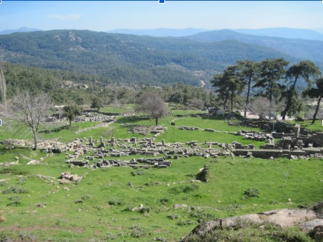
Modern archaeology long inherited this confusion. For generations, scholars viewed Caria through a lens of absence. Because the region did not fit the template of a centralized state dominated by a single urban elite, it was frequently categorized as peripheral, backward, or merely “Hellenized” — a passive recipient of Greek, Persian, or Anatolian influences. The physical remains of Carian culture — isolated mountain sanctuaries, rock-cut tombs perched above river valleys, processional ways stretching across miles of empty scrubland — were treated as scattered anomalies, footnotes to the greater stories of Ephesus, Athens, or Persepolis.
But this diagnosis of absence relies on a fundamental assumption: that culture is something forged exclusively by human hands upon a passive, neutral stage. We have been conditioned to look for civilization in the concentrated, the monumental, and the monumentalized — in the single temple that commands an acropolis or the written codex that codifies a law.
What if this assumption is precisely what obscures the intelligence of Caria? What if Carian society was not a failed attempt at an empire, but a brilliant, highly sophisticated response to a very specific set of physical conditions?
To understand Caria, we must abandon the idea of the landscape as an empty canvas. We must ask a different, more demanding question: Can a landscape actively participate in creating human culture?
The Myth of the Neutral Canvas
For over a century, the social sciences have approached the natural world through two opposing, yet equally reductive, frameworks.
On one side stands environmental determinism. Popularized in the nineteenth and early twentieth centuries, this view posited that geography was destiny: climate, topography, and soil quality directly dictated the intelligence, political structures, and economic outcomes of human populations. In its coarsest forms, determinism reduced human agency to a simple equation, claiming that flat plains naturally produced autocracies, while jagged coastlines bred seafaring democracies. Because of its rigid, often racially charged oversimplifications, environmental determinism was rightly discarded by modern scholarship.
In reaction to this, human geography and anthropology swung to the opposite extreme: cultural constructivism. Here, the physical world was stripped of all agency. The landscape became nothing more than a passive backdrop, an arbitrary stage upon which humans projected their social meanings, economic ambitions, and religious fantasies. A mountain was merely a pile of rock until a priest named it sacred; a river was simply moving water until a merchant turned it into a border. Human culture, in this view, was an entirely internal, self-contained phenomenon — a matrix of language, power, and symbols operating independently of the earth beneath its feet.
Both frameworks suffer from the same blind spot. They separate the human mind from the environment it inhabits. They treat the brain as a central processing unit that receives external data, processes it internally, and then executes actions upon an unfeeling world.
In recent decades, however, breakthroughs across cognitive science, environmental humanities, and spatial archaeology have begun to shatter this duality. Scholars of embodied cognition have demonstrated that human thought is not confined to the cerebral cortex. Our cognition is deeply, fundamentally entangled with our physical bodies and the environments through which we move. We do not think about space from a distance; we think with space. The physical architecture of our surroundings — its textures, inclines, acoustic qualities, light patterns, and spatial boundaries — shapes our memory, directs our attention, and anchors our social structures. When we re-examine Caria through this interdisciplinary lens, a new hypothesis emerges.
Caria was not a civilization that happened to exist in a rugged landscape; it was a culture whose very intelligence, social organization, and religious life were co-invested in the physical terrain. Instead of asking how humans masterfully shaped Caria or how Caria rigidly dictated human fate, we must ask how the Carian landscape functioned as a dynamic environment that encouraged certain modes of perception, movement, and social cohesion while making other forms more difficult, costly, or less durable.
An immediate counter-question arises for any rigorous scholar: Why Caria? The Mediterranean basin is filled with dramatic topographies. High mountains define Lycia to the east; deep, isolated valleys slice through Arcadia in the Peloponnese; arid plateaus characterize Pisidia; island topographies define Crete. Why did a specific spatial intelligence emerge in this particular pocket of southwestern Anatolia?
The answer lies not merely in ruggedness, but in topographical and ecological density. For the purposes of this essay, we might describe Caria as a high-resolution landscape: a terrain in which ecological, sensory, and topographical transitions occur at unusually short intervals.
In many parts of Caria, especially where inland basins, karstic uplands, wooded ravines, and deeply indented coasts approach one another, striking environmental transitions occur within relatively short distances. A traveller can pass from an arid limestone plateau into a shaded pine ravine, step across a subterranean spring bursting from a karst cliff, and descend into an olive-rich valley basin within a short journey.
Geologically, karst formation means the ground beneath one’s feet is never entirely static or solid. Waterways vanish underground without warning and re-emerge miles away as sudden, high-volume springs. Caverns, sinkholes, and rock clefts puncture the terrain at every turn. Furthermore, the stark shift from exposed limestone to shaded river corridors creates continuous microclimatic friction.
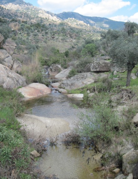
Such a landscape repeatedly rewards close environmental knowledge and makes orientation, seasonal memory, and bodily familiarity especially valuable. It creates recurring situations in which attention becomes consequential. Navigation presents the body with continuous micro-choices: evaluating footing on slippery karst limestone, choosing between branching canyon passes, anticipating the loss of shade, searching for water where a stream goes dry, or pausing at a natural col where the wind and visual horizon abruptly shift.
Landscapes do not possess conscious intentions; they do not “want” to create culture. But a high-resolution landscape acts as a dynamic frame. By continually presenting the human body with physical decision-points, it shapes the conditions under which perception operates.
The Architecture of Attention: From Terrain to Memory When we say that landscape participates in creating culture, we are describing a precise, step-by-step cognitive chain. Landscapes shape bodily decisions. Bodily decisions organize human attention. Organized attention creates repeated behaviours. Repeated behaviours consolidate into collective memory. And collective memory becomes the foundation of culture and religion.
The critical, often overlooked link in this chain is attention. Landscapes do not create culture directly. Landscapes organize human attention. Human societies organize attention through many interacting media: terrain, architecture, roads, boundaries, images, sound, and ritual movement.
In Caria, the unusually compressed transitions of the terrain may have played an especially visible role within that larger system. The landscape did not function as a technology by itself; it became one through the reciprocal work of routes, sanctuaries, ritual practices, and generations of moving bodies.
Where three mountain passes converge at a narrow col, human movement is naturally funnelled into a single point. Attention naturally spikes at this node because navigation requires a decision. Such nodes may attract markers, offerings, gathering practices, or eventually more formal sacred architecture — not by necessity, but because they repeatedly concentrate movement and attention.
Similarly, a steep limestone amphitheatre or a cave entry alters sound — the drip of subterranean water, the echo of a voice, the rush of wind. Human perception naturally zeroes in on these spatial anomalies. Such acoustic properties could contribute to practices of listening, performance, or ritualized speech.
A sudden break in a canyon wall that reveals a vast valley basin or a distant mountain peak creates a natural perceptual pause. Movement slows; the eyes adjust to the expanding horizon; the scale of perception changes. The physical threshold creates a psychological state of liminality.
Because such features repeatedly influence where bodies stop, look, listen, and make decisions, they can support recurring collective practices. People begin to pause at the same spring, assemble at the same mountain, and mark the same cave mouth.
Over centuries, these repeated patterns of shared attention solidify into tradition. Tradition becomes codified as ritual. Ritual anchors collective memory. And collective memory forms the bedrock of an enduring cultural identity. The durability of Carian identities may therefore have depended in part on a landscape that repeatedly renewed the spatial practices through which communities oriented themselves, assembled, and remembered.
This attention-organizing framework helps explain why Carian political centralization repeatedly coexisted with a distributed sacred and territorial system, a distributed Ecosystem.
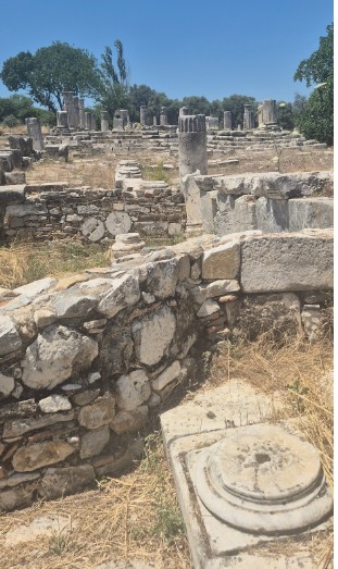
If you walk through the ruins of Stratonikeia — one of the major inland cities of late ancient Caria — you quickly realize that the city itself is spatially incomplete without its surrounding territory. Although cities such as Miletus or Priene articulated civic identity through strongly defined urban centres, their political and religious worlds also extended into surrounding territories. In Caria, however, the relationship between city, route, landscape, and extra-urban sanctuary often became unusually prominent and ritually explicit.
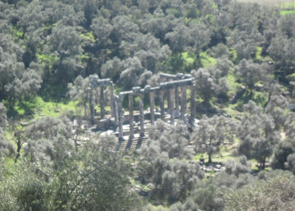
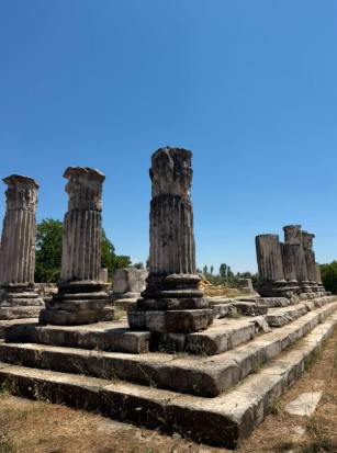
Stratonikeia was tethered to a site six miles away: the Sanctuary of Hekate, Lagina. During major festivals, the city reoriented itself toward the landscape, processing along a sacred road across hills, riverbeds, and ravines to reach the shrine. Similarly, the ancient city of Mylasa was permanently bound to the sanctuary of Labranda, set high in the mountains above Mylasa, among gneiss outcrops, springs, and monumental terraces.
In an ecosystem, no single node holds all the information or resource capacity of the system. Meaning, power, and identity are held in the relationships between nodes. The terrain repeatedly complicated complete and durable centralization, even when powerful dynasties such as the Hekatomnids attempted to reorganize the region around monumental centres.
The landscape is naturally partitioned into semi-isolated valleys separated by formidable limestone ridges. Each basin offered arable land, but no single basin was vast enough to support a megalopolis that could permanently subjugate the rest.
Rather than concentrating civic, religious, and economic life in one urban centre, Caria distributed these functions across distinct landscape types: mountain peaks associated with seasonal assembly and divine authority; low, watery valley basins associated with communal ritual, memory, and threshold guardian deities; and coastal promontories serving as nodes of maritime trade and external exchange.
The true centre of Carian culture was neither the city nor the mountain shrine alone, but the network of pathways, mountain cols, and processional roads that stitched these diverse environments together.
To live in Caria was to be in constant spatial motion between different ecological and symbolic zones. Identity was not static; it was performed through transit. A Carian was not simply a citizen of a specific town, but a participant in a broader territorial circuit.
This distributed model explains why Carian culture exhibited such remarkable resilience across centuries. Imperial powers — from ancient regional powers to the Persians, Hekatomnids, Greeks, and Romans — could conquer individual Carian towns, but Carian identity remained rooted in a network of mountain shrines, sacred caves, and processional paths embedded deep within the rock.
To understand how this spatial order was reproduced across generations, we must examine one of its most visible ritual mechanisms: the processional journey.
Modern mobility is obsessed with speed and efficiency. We view the distance between our departure point and our destination as dead space — an unfortunate obstacle to be overcome as quickly as possible. When we travel, we retreat into insulated bubbles, staring at screens or highways designed specifically to minimize our engagement with the terrain we are crossing.
In the ancient Carian ecosystem, this relationship was inverted. The journey was not the cost of arrival; it was a primary cultural act.
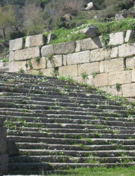
Consider the Sacred Way connecting Stratonikeia to Lagina. This was a paved avenue engineered to cut across miles of undulating terrain. During major festivals, participants travelled between Stratonikeia and Lagina along the sacred route connecting city and sanctuary. The ceremonial transport of Hecate’s sacred key made this connection not merely geographical but ritually enacted. Among those who walked the route were priests, civic officials, performers, worshippers, attendants, and sacrificial animals.
If we view this procession merely through the lens of traditional sociology, we see a display of political hierarchy or religious conformity. But if we analyse it through the lens of spatial cognition and embodied memory, a far more sophisticated technology becomes visible.
Prolonged collective walking can coordinate pace, gesture, vocal rhythm, and attention, producing a bodily experience of belonging that cannot be reduced to doctrine alone.
Processional routes also contained — or naturally produced — points of interruption: springs, changes of gradient, boundary zones, and places where the sanctuary or surrounding terrain came newly into view. Whether formally prescribed or generated by the demands of the route, such pauses could reorganize attention, allowing the sensory impact of the landscape — the change in wind, the smell of resin, the panoramic view of the valley below — to re-enter the consciousness of the participants.
In a culture without mass printing or digital media, complex cultural memory was anchored in the muscles, joint receptors, and spatial maps of the human body.
For a participant who walked such routes repeatedly from youth, sacred geography could be learned not only as doctrine but through gradients, temperature changes, exertion, and recurring visual sequences.
The landscape functioned as a living mnemonic framework. Rocks, springs, ravines, and mountain cols were linked to ritual moments, mythic narratives, and civic obligations. Cultural identity was inscribed into the earth and re-read through movement along sacred paths.

Thresholds, Sacred Paths, and the Gates of Lagina Such a landscape did not mechanically produce threshold deities. It did, however, provide unusually durable experiential structures through which boundaries, passages, hidden water, orientation, and safe movement could acquire deep religious significance.
Carian religion accommodated many divine powers. The granite and gneiss heights of Labranda belonged to Zeus Labraundos, whose double-axe, the labrys, and mountain sanctuary spoke to storm, authority, and ancestral sovereignty. Apollo appeared in several locally differentiated Carian cults, sometimes in relation to sacred landscapes, springs, or oracular practices.
But this landscape also gave unusual experiential force to another religious vocabulary: passage, orientation, guarded boundaries, hidden depths, and movement between differentiated worlds. Within that vocabulary, Hecate becomes especially revealing.
At Lagina stood the monumental sanctuary of a goddess whose cult placed exceptional emphasis on guardianship, passage, civic protection, and the ceremonial movement of the sacred key (kleidophoria). Elsewhere in the Greek world, Hecate would also be associated with torches, roads, doorways, and crossroads.
In later Greek and Roman traditions, Hecate’s nocturnal and chthonic dimensions would increasingly dominate her literary image. At Lagina, however, she stood within civic life: guardian, key-bearer, protector, and the focus of a ritual network connecting sanctuary, city, road, and region.
If Caria teaches us that landscapes can organize attention, Hekate poses the next question: what kind of deity becomes central to a culture that repeatedly learns, through movement, to inhabit thresholds?
To be continued –
All of the images are accredited to Timea Kutlu
Selected References
- Bender, Barbara (ed.). Landscape: Politics and Perspectives. Berg, 1993.
- The Histories.
- Herring, Amanda. Hekate of Lagina: A Goddess Performing Her Civic Duty. Anatolian Studies 72, 2022.
- Ingold, Tim. The Perception of the Environment: Essays on Livelihood, Dwelling and Skill. Routledge, 2000.
- Malafouris, Lambros. How Things Shape the Mind: A Theory of Material Engagement. MIT Press, 2013.
- Tilley, Christopher. A Phenomenology of Landscape: Places, Paths and Monuments. Berg, 1994.
- Varela, Francisco J., Evan Thompson, and Eleanor Rosch. The Embodied Mind: Cognitive Science and Human Experience. MIT Press, 1991.
- Williamson, Christina G. City and Sanctuary in Hellenistic Asia Minor: Constructing Civic Identity in the Sacred Landscapes of Mylasa and Stratonikeia in Karia. University of Groningen, 2012.
